
Old roads and new: Mbeya-Mwanza. Part 1
The flights were booked well in advance. Mwanza-Dar-es-Salaam, then Dar-es-Salaam-Mbeya. Less than £90 in total, including the extra luggage allowance for the bike in a box.
The tour had been on my mind for months – around about the same time I booked the flights I guess. Beyond a rough route, which would bring me back to Mwanza by bike, I had little specifically planned for what ended up being 7 weeks on the road.
The Southern Highlands of Tanzania would be first up, an area of the country I’d yet to cycle through. Then I’d cross Lake Niassa to Malawi and ride north, possibly heading into Zambia and connecting with the ferry service across Lake Tanganyika to Kigoma in Western Tanzania. If there was time I’d revisit Burundi and Rwanda, dip into Uganda and then return to Tanzania. One thing I was sure I wouldn’t do, unless absolutely necessary, was subject my bicycle and bottom to the discomfort of an African bus.
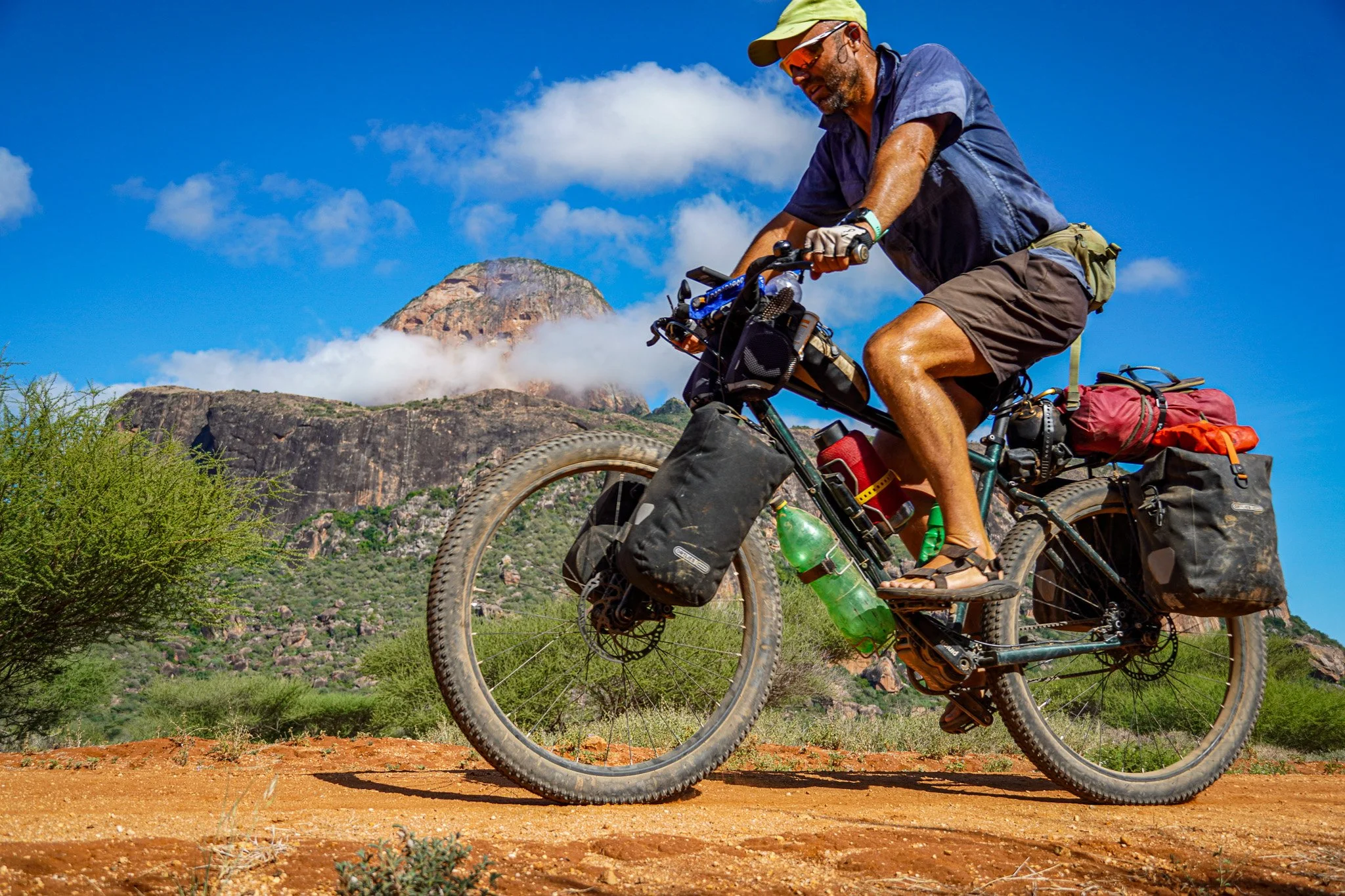
The journey wouldn’t be short of climbs given that most of my intended route would pass through the Rift Valley. In fact there were very few flat days on the tour. In total I rode just under 3200km, in 38 days, and accumulated 36,458m of altitude, according to my GPS unit.
It was a great tour – both on and off the bike, riding a mixture of paved and unpaved roads and revisiting a few places I’d been before. I’ll do my best to share it here with pictures and descriptions over a series of blog posts.

It’s a perfect day and a perfect road to roll out of Mbeya on. Starting at 1700m the air is cool and it’s uphill all day – 25km on smooth tarmac then 25km on a dirt track towards Kitulo National Park. I’m in relatively good fitness, but 20kg of luggage, plus water, feels like a serious work out.

Buying local fruit and veg on the roadside has to be one of the most enjoyable aspects of cycling in Africa. People try to flog you an entire bucket of whatever is in season, unaware that carrying 5kg of carrots or tomatoes in your panniers isn’t sensible. And so you offer some small change and pick a handful, which is usually OK. I stopped to buy plums here, rare in Tanzania. Also nice to get service with a smile.

Room for the first night in a village called Kikondo. Pretty basic and pretty grim, but clean enough and at £1.80 per night I couldn’t really complain. It was the only Guest House in Kikondo (unsigned) – 10 tiny rooms or so behind a bar. I could have camped, but wimped out under dark skies. Kikondo is at about 2800m altitude so I asked the receptionist/bar girl to prepare some hot water for a shower. I turned in for the night early, happy the village’s limited power supply meant all was quiet by 10pm. Tanzania is one of Africa’s easiest countries to find cheap accommodation in. Naturally the choice, quality and price go with the size of the place.

On the second day I entered Kitulo National Park. It’s one of Tanzania’s lesser known parks (no big animals here) and is mostly situated at over 2000m in altitude. Between Jan-Feb wild flowers cover many of the slopes, so I was a month or so early.

Road through Kitulo National Park. Why does a giraffe and lion reside on my handlebars? No particular reason other than they were being sold off cheap on an online store when I was purchasing various other gear, and felt like pimping the bike up with some random mascots. Just a kid at heart really. Front light is also a new edition, wired up to the dynamo hub, although I rarely used it and found the placement right on the front of the rack to be too susceptible to the occasional knock. Will have to rethink that one.

Almost no traffic on this track heading to Makete in the Southern Highlands. I had read that December was the wet season, so was perhaps lucky that almost no rain fell during the first week. On some of the tracks, wet weather would have made the going very hard.

There were many tracks in the Southern Highlands and it wasn’t always obvious which one to take. I had download a GPS app on my phone, which showed hundreds of interconnecting tracks. I usually just followed my instinct and took whichever was going in the right direction.

Food options were fairly limited in the Southern Highlands, but surrounded by fields of potatoes it wasn’t hard to find a plate of fresh chips. And coke, well coca-cola is never that hard to find in Africa.

The scenery was superb, but the gradients on this track through the Southern Highlands were amongst the steepest I have ever cycled on (typically 12-18%+). Down one valley side and up another – all day. In the lowest gear I would usually cycle for a few hundred metres at 4-5km/hr, rest and drink water, then continue. Pushing the bike (about 45kg) on loose surfaces meant it was impossible to get any grip. Had there been rain such roads would have become very difficult to ride. This was the third day of riding on the tour and I managed 35km in about 6 hours, climbing 1200m. When I arrived mid-afternoon in the small village of Lupila I was told I had taken the short-cut, which probably meant the track people walk on.

This photo was taken about 2 hours after the previous, and probably only about 10km later. You can see the road snaking around to the right of the picture. The reward for such a sweaty workout were the stunning views over the Livingstone Mountains.

Nice to find some shady spots on this track to Lupira.

The views around the remote mission station of Lupira were really quite dramatic. The road I should have arrived on cuts into the mountainside on the top right of this picture. This picture is looking north.

Tanzania’s National Roads Authority (TANROADS) website has a surprisingly good database of maps detailing the network of roads in the country. I took a series of screenshots of the road network in the Southern Highlands on my phone, which turned out to be very useful and accurate as the names used here are those in existence. GPS devices and paper maps occasionally use inaccurate names. Lupila, which really felt like the middle of nowhere due to the difficulty in reaching it, doesn’t actually appear on most maps.

The weather and scenery continues to keep me happy as I head south from Lupira on day 4.

Few people live in a region that’s probably one of the most fertile in the country. The population of Tanzania is growing rapidly, but it’s towns where people want to live – the same throughout most of Africa. Tanzania as a whole remains sparsely populated and in the areas where roads are poor and mobile network non existent, such as this one, that isn’t likely to change too quickly.

Looking westwards towards the Livingstone Mountains, the other side of which lies Lake Malawi.

Without much notice the road to Mlangali (day 4) suddenly came to an end at the bottom of a valley, where a small team of workers were constructing a bridge. With a little assistance I was able to push my bike across the other side and continue, something which reminded me of the simplicity of being on a bicycle.

After several hard days since leaving Mbeya, the road, at least for a short distance, followed a valley floor as I continued south to the town of Ludewa. This photo was taken in the late afternoon and I soon realised that in such scenic surroundings with no sizeable villages or towns in cycling distance, it would make for a good place to camp

Always exciting to spend your first night in a new tent. This is the MSR Nook, a relatively new tent from the same manufacturer that makes the very popular, and excellent, Hubba Hubba, which I had used for many years previously. I still have the Hubba Hubba, but the rain-sheet has lost most of its waterproofness after 400+ nights in it. I expected this tour to be wet at times, which it wasn’t, and so felt it was time for a new tent. MSR have supported me before with their gear, but at the time of starting this journey the new MSR Hubba Hubba NX was out of stock. I was offered a good price on the Nook, which has a tunnel design and is more compact and slightly lighter than the Hubba Hubba, so decided to give it a go. I’ll write in more detail about it elsewhere, but this was a nice spot to pitch up in – surrounded by Miombo woodland and a backdrop of mountains on either side of the valley.

Great mountain scenery and views of Ludewa District at about 2000m altitude here.

At the end of a hot and dusty road on the shores of Lake Nyasa (Lake Malawi) lies Manda Bay. After 5 hard days on the road it was great to swim here, although I soon missed the comparatively cool mountain air.

I packed a few books with me for the tour, one of which being a biography of David Livingstone. Turns out the much feted hero of African exploration wasn’t such the saint many have held him up to be, ultimately failing in his endeavours to convert Africans to Christianity and in finding the source of the Nile. Having said that, his accomplishments in terms of how much of the continent he explored remain impressive, although no mention is made in the book of the Kipengere Moutain Range, which rise up from the north eastern shores of Lake Malawi and are commonly now called the Livingstone Mountains.

Livingstone may have failed in his direct objectives, but his legacy and that of other missionaries who followed in his wake have remained a strong influence in many parts of Africa. The population in the Southern Highlands of Tanzania are predominantly Christian and many old churches, such as this one pictured here a few kilometres south of Manda Bay, are a common sight. Remote and scenic places seem to be common denominators for the location of missions, although living next to Lake Malawi was never a very sensible decision for European missionaries. Malaria remains prevalent and it’s bloody hot.

A short distance south from Manda Bay the Ruhusu River drains into Lake Malawi. There is no bridge so small boats transport passengers across. ‘Any crocs?’ I asked the young boy paddling me across. ‘Over there’, he points to a bank of dense reeds upstream.

Heading south along the shores of Lake Nyasa (Lake Malawi). The cool blueness of the lake and sky provided little relief to the relentless heat. This dirt track, highly scenic as it was, also followed the rule that no gradient is too steep.

Never hard to find a smile in Tanzania, most of Africa for that matter. Villages are full of children. 45% of Tanzanians are under 15 years old, 65% under 24. The statistics, shocking as they sound, are easy to believe. This was taken in a village along the shores of the Lake where I stopped for a warm coke.

A gaggle of women standing on the road ahead caused me to stop. The excitement was for the new born baby – just 2 days old, swaddled in a blanket within his teenage mother’s arms. ‘Give a gift for the new born’ they all shouted. A handed over a small sum of money. There were then cheers and I asked for a picture, thinking as I took it that this would have made a better gift. But I was a long way from anywhere with electricity, let alone a photo printing shop

Arriving in Mbamba Bay. I first visited this quiet backwater 14 years ago when backpacking around east and southern Africa. Like other places I have revisited since, it hasn’t changed other than the appearance of several mobile telephone masts. There is still no electricity and the roads leading here remain unpaved. Places like this, far far away from the commercial capital Dar es Salaam, are mostly forgotten about.

Mbamba bay is about as far south as one can go in Tanzania before crossing into Mozambique, which wasn’t the plan. Fourteen years ago I took a memorable boat from here, travelling north and docking at many of the Tanzanian lakeside villages through which I’d just cycled. This time I wanted to go directly across the lake to Nkhata Bay in Malawi, but there was no official schedule. I was in no particular rush to travel, but didn’t have endless time to wait for a ride. Fortunately it was only a few days before I met the owner of the large boat pictured here. Yes he would be going to Malawi, but not Nkhata Bay. Likoma Island was his destination, a Malawian Island close to the Mozambican mainland. It sounded like an adventure. We agreed a price (about £10) and I was told to return the following evening. I thought about asking if there were life vests onboard, but already knew what the answer would be.

