
Turkana Transit: Mwanza-Muscat Part 7
I knew a 3-day transit visa wasn’t long enough. So did the Kenyan immigration officer. We unfolded my map on the only desk in his office and counted up the distance. Almost 400km to reach Ethiopia and most of those would be on unpaved roads.
‘You would be better taking a tourist visa’ he advised.I wasn’t in the mood to pay $50 for a 90-day tourist visa when all I wanted to do was transit into Ethiopia.
‘This area is very remote. Few people. Something might happen to you. There isn’t even any Kenyan immigration post on the border with Ethiopia’, continued the official, whose finger was now nudging the western side of Lake Turkana on a map I thought I wouldn’t be needing again.
‘No immigration?’ I clarified. ‘Well I think a transit visa will be fine for me’.A desk drawer was opened and the official took out a rubber stamp and receipt book. ‘That’s $20 then’.
My swift deportation from South Sudan had given me little time to look at the map and roads I’d now need to take in northwest Kenya in order to reach Ethiopia.
‘You’re a braver man than me’, said a voice at my back several hours later in a Somali-owned shop in Lokichokio. That’s how long it had taken to cover the first 27km. The few other vehicles I’d seen on this stretch had armed security guards with them, although the Kenyan immigration official had seemed nonchalant enough about the risks when I asked him if I could cycle.

I hadn’t actually seen anyone at all until the final few kilometres when several Turkana boys with guns pointed at the water in my bottles. Knowing I wasn’t far from the town I promptly stopped and offered them some tepid refreshment.
‘The name’s Mike Rogers’ introduced the elderly man. He was short in statue and wearing a wide-rimmed sun hat.
I suspected he must have been a missionary. When anyone introduces their full name when I’ve just met them I always assume they must be a missionary. It’s like some kind of code to say who they are without having to explain any further. Had I replied ‘Peter Gostelow’ he might have gone on to ask who I was with. I could then have pointed at my dust-covered bicycle that I was keeping a close eye on outside.
This didn't happen and I was soon back on the bike with the $50 worth of Kenyan shillings I’d just changed with the Somali shop owner, checking in to a nearby lodge. It was the first bed I'd slept on in almost 10 days. Good value for $7.
I had no idea until I decided to do a Google search later that evening that Lokichokio was once a booming hub for NGOs and UN activity working across in South Sudan. Neither did I know until I started the next day’s ride on smooth tarmac (the first in 600km) that I would be cycling into and staying in a town accommodating around 200,000 refugees.
Kakuma is Kenya’s second largest refugee camp, established almost 25 years ago during Sudan’s civil war. The camp itself, which I never saw up close, was off the main road, but it was obvious from the mix of faces and skin colours on my way in that not just South Sudanese refugees had made their way here.
As perhaps should befit a town full of refugees the Guest House I stayed in here wasn’t a place I’d wish to spend a second night. A room that might cost $3 elsewhere in Kenya (based on its level of grimness) was going for $8 here, the price driven up by the local NGO presence probably.
Two of the guests here were in fact from South Sudan, referring to themselves as returning refugees.
‘We like to get out of the camp from time to time’, said one of the two smartly dressed men playing with a large smartphone.
‘Is that an S5 or S6?’, he asked looking at my phone.‘It’s an S4, a few years old now', I explained.
I was as much surprised by meeting my first two refugees from Kakuma as I think they were when I explained I’d just cycled through their country.
I later met another well-dressed refugee, this time from the DRC. He’d been in Kakuma over 10 years and spoke English with no hint of his Francophone roots. Like many refugees he explained he was waiting for his papers to be processed for resettlement, hopefully in the States.
Had there not been the small issue of my visa that was soon going to expire I would have taken the Congolese man’s offer up on visiting the camp. What does a refugee camp, over 20 years old and home to almost 200,000 people from perhaps a half dozen or more African countries look like?
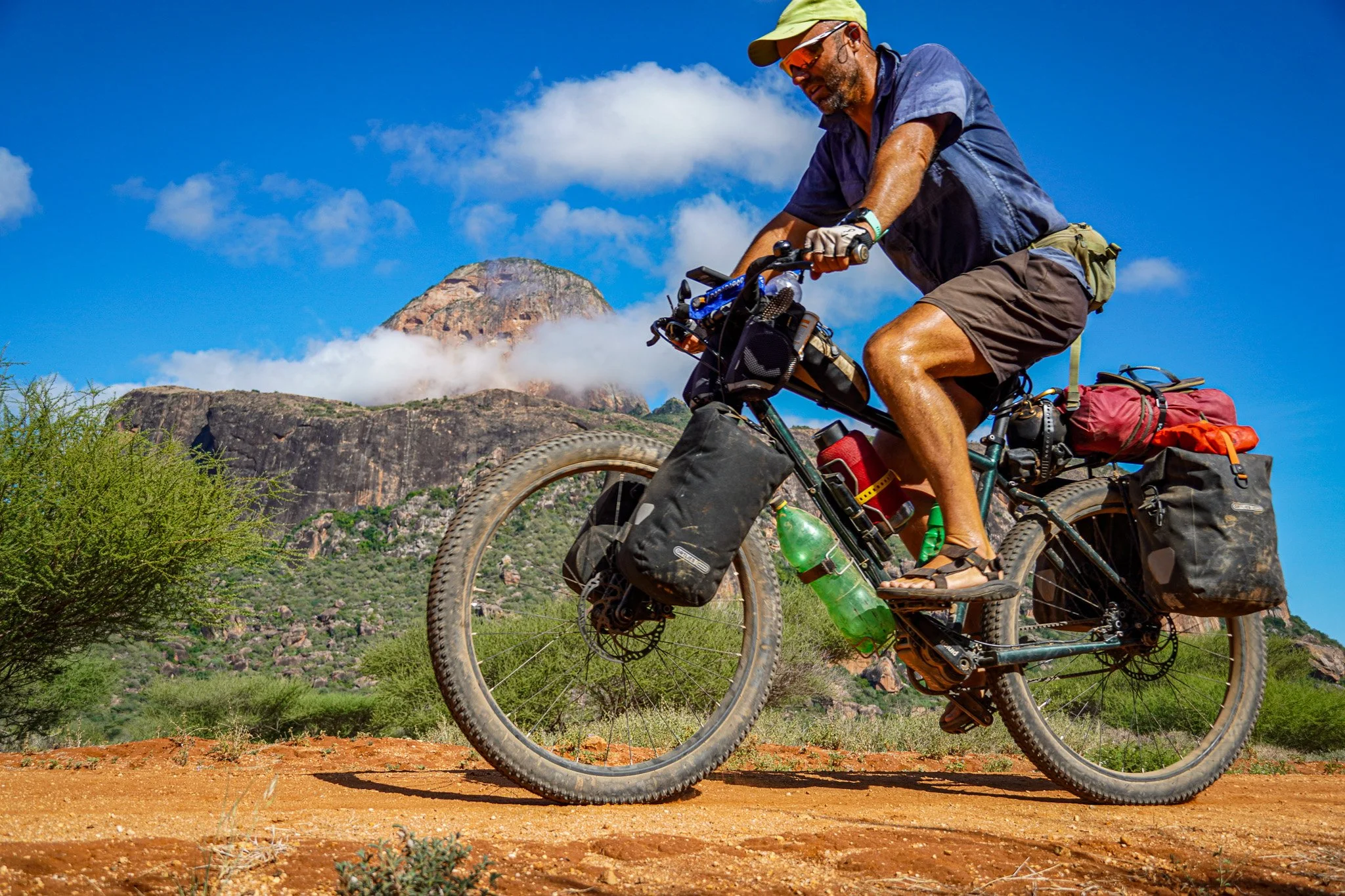
Kenya seemed hotter than South Sudan. It was certainly drier and the landscape more arid. By 10am any water I was carrying would become unpleasantly warm to drink. I wondered how long I could survive out here without it. If I saw someone with jerry-cans I would ask where the nearest bore-hole was. Whenever there was a chance to fill up, which wasn't often, I would make sure I did.


As I guessed I’d be camping for the remainder of my time in the country I made use of my 10-litre water bladder, strapping it onto the back of the bike. This allowed me to transport around 16-18 litres of water, depending on how many plastic bottles I also had. Hot water isn’t very effective at quenching one’s thirst. I consumed around 10 litres of it daily.


The local Turkana tribe appeared far less curious and shocked at the sight of me passing them than their neighbours to the north. With all the NGOs and missionary activity up here I suspect white faces are far less rare, even if most of them fly in and fly out of the airstrips dotted around.
The discomfort of the heat and road ahead over the next several days was compensated by an arid landscape of changing contours and colours that felt nowhere like the rest of Kenya I’d been to. I’d always heard that northern Kenya was like a different country to the south.


")

The nights in my tent were almost as hot as those on the bike, until I realised that in order to not lie on a bed of hot sand, which I did on two consecutive nights, I needed to pitch the tent somewhere that had been out of the afternoon sun. The shade of a tree beside a dry riverbed was the most obvious place. This also provided the added advantage of allowing me to hang a shower bag from one of the branches.


The cycling was hard and slow, particularly when the wind was against me. And just when I thought the road surface couldn’t get much worse I found myself following the course of a riverbed, descending from the small town of Lokitaung towards Lake Turkana.There are various surfaces that disagree with a bicycle - riverbeds composed of loose rocks and stones are one. And so I ended up pushing the bike for most of 15km wondering how the track had ever been drawn onto the map.
I had visions of turning a corner on this meandering course and setting my eyes on a shimmering turquoise lake. The reality was I never got anywhere near enough to Lake Turkana to say I’d really seen it. Sand replaced stones and I was almost as much off the bike and pushing it as I was on and trying to keep my balance.


Of the two principal overland routes between Kenya and Ethiopia it was hard to believe this was one of them. I relied as much on the GPS app on my phone (maps.me) to guide me north as I did the rare Turkana shepherds tending a herd of goats or camels. This truly felt like a land the rest of Kenya had forgotten.


‘It last rained for a few hours in January I think’, said one of the police officers in Todenyang. This was quite literally the end of the road in Kenya. What a place to be deployed to work I thought. A furnace. Miles from nowhere.
I was a little hesitant about stopping here to ask for water in case one of the officers asked to check my passport. They would have realised the visa expired two days previously, but I doubt anyone would have cared much. There was no telephone reception.

One of the older officers invited me for lunch (lentils and rice) and poured me some cold water from a jerry can covered in hessian sacking.
‘Sorry there is no fish. Those fools are always fighting’, said one of the officers as I struggled to keep a growing number of flies out of the food. He was referring to the usual livestock raiding between the Turkana and the Dasenech tribe from Ethiopia, who just the previous night had apparently stolen hundreds of goats.
‘Don’t worry they won’t harm you’ he laughed.‘How far is Omorate?’ I asked once the flies got the better of my food and the officer said I could throw the scraps towards a couple of scrawny chickens resting nearby.‘Oh it’s far. And the road man. It’s shit shit shit. Just sand and then mud on the Ethiopian side before you cross the river to Omorate. ‘You know you should write to our government and tell them’.
I suspected the government already knew and didn’t really care. Practically no-one lived up here. And if people were running around with guns and stealing livestock in a place where it never rained it was hardly an incentive to build a better road and encourage development.
‘Now is time for rest’, said the officer who soon took his leave and disappeared in the direction of one of the rooms in the open courtyard.I finished filling up the water bottles and rolled my bike back out into the afternoon sun.**The route for this section of the trip can be seen at the bottom of the page here.**

